405, please remember to sign off with your name when you post as well as comment.

Wednesday, April 27, 2011

How do Clouds Form

While there are a wide variety of cloud shapes and sizes, they are all made of the same thing: condensed water or ice. Clouds form when rising air, through expansion, cools to the point where some of the water vapor molecules "clump together" faster than they are torn apart by their thermal energy. Some of that water vapor condenses to form  cloud droplets or ice crystals which can be observed by us.
formation of a convective cloud

 To be more specific,  in order for these water droplets or ice crystals to form into clouds in the atmosphere, a series of processes have to happen, and different types of clouds form from different processes. The four main ways that clouds can form are:
-Surface Heating
-Mountains and Terrain
-Weather Fronts (cold or warm)
-Air Masses Being Forced to Rise
All of these processes involve the cooling of air. Warm air is able to hold larger amounts of water vapor than cool air, so when air cools it is no longer able to hold all of the water vapor it was able to hold when it was warm. This extra water vapor begins to condense out of the air into liquid water droplets.

there are five main types of clous, which are , cirrostratus clouds, cirrocumulus clouds,altocumulus clouds and cumulus clouds.
cirrus cloudsthere are also four types of cirrus clouds. two kinds of cirrus clouds that we should know is  cirrus Fibratus dsand Spissatus. they are all ice clouds, if you see these to kinds of clouds, it means it is a good wather now. however, the weather also depend on the winds. if the winds are from the E to S, precipitation is likely to occur with 20 to 30 hours of that time period too.

Fibratus

Spissatus
there are 3 types of cirrostratus clouds. these clouds cover up the whole sky. these clouds contain ice. if you see these clouds in the sky, it means that precipitation is likely to occur in 15 to 25 hours.
cirrostratus clouds
cirrocumulus clouds
cirrocumulus clouds are all ince clouds. if you see these clouds in the morning, then that means you will likely to see come thunderstrom showers in the afternoon.
Cirrocumulus
Altocumulus Clouds
Altocumulus clouds are mostly water and ice clouds. one type of altocumulus clouds, undulatus clouds, is the sign for heavy rain.
Undulatus
Cumulus Clouds
Cumulus clouds are the most common clouds. There are 4 types of Cumulus clouds; Humilis, Vertical Growth, one kind of cumulus clouds that we should know is Vertical Growth can also occur during fair weather conditions and can spawn afternoon showers. 
Humilis
Vertical Growth
Hope everyone can learn from what i post, clouds formation is amazing right ?!!? :D
Zhou Weixin(25)  JH 405
reference:

Saturday, April 9, 2011

The hydrologic cycle and different drainage patterns

The hydrologic cycle is the journey water takes as it circulates from the land to the sky and back again. It is a conceptual model that describes the storage and movement of water between the biosphere, atmosphere, lithosphere, and the hydrosphere. Water on our planet can be stored in any one of the following major reservoirs: atmosphere, oceans, lakes, rivers, soils, glaciers, snowfields, and groundwater. Water moves from one reservoir to another by way of processes.

Components (processes and terms) of the hydrologic cycle and their definitions:
  1. Evaporationthe process by which water is converted from its liquid form to its vapor form and thus transferred from land and water masses to the atmosphere. 
  2. Precipitation—water falls back to earth from the atmosphere as rain/snow.
  3. Infiltrationthe process by which water on the ground surface enters the soil.
  4. Condensationthe change of the physical state of water from gaseous phase into liquid phase, 
  5. Surface runoffthe water flow that occurs when soil is infiltrated to full capacity and excess water from rain, or other sources flows over the land. 
  6. Evapotranspiration—movement of water from soil and plants to the atmosphere.
  7. Interception—water is intercepted by plants and trees.
  8. Through flow—water that flows horizontally in the soil zone.
  9. Water vapour—gaseous phase of water
  10. The Earth's Water Budget – the distribution of water among the oceans, land and atmosphere.
Putting everything together:
The total quantity of water on the earth remains essentially constant. Water moves about from high ground to low ground, changing location and form (vapor, liquid, solid) as part of the hydrologic cycle. Water vapour in the atmosphere condenses due to the cooler temperature to form clouds (condensation).  Water is delivered to the earth as precipitation (rain or snow) and then seeps into the ground (infiltration) or travels over the ground (surface runoff). Some of the water moving over land or in streams and lakes is lost to the atmosphere as water vapour through evaporation. In addition, plants extract water from the ground and release it to the atmosphere as water vapor (transpiration). Water loss to evaporation and transpiration are referred to collectively as evapotranspiration. Water that has seeped into the soil moves along as through flow and water which runs off to streams moves as stream flow. J

A simple diagram to illustrate the hydrological cycle:


Further Learning on Hydrologic Cycle:

Figure 2: Hydrologic Cycle


A good website for further reading on hydrologic cycle:
http://www.eoearth.org/article/Hydrologic_cycle


Different Drainage patterns

 Dendritic drainage pattern


Trellis drainage patterns


 Radial drainage pattern

Other drainage patterns include: rectangular drainage pattern, parallel drainage pattern, centripetal drainage pattern, deranged/contorted patterns.

A very good website for more information: http://www.uwsp.edu/geo/faculty/ritter/geog101/textbook/fluvial_systems/drainage_patterns.html

Thank you. :) Hope you have learnt something.
Yang Yi Chao  JH405  15 :)

References:


 Re

Wednesday, April 6, 2011

Types of rainfall

Hi everyone! I'll be sharing with everyone about the different types of rainfall today. Some might wonder, rain is simply water droplets falling back onto earth, how different could it possibly get?! But yes, there're in fact 3 different types of rainfall, and I'll be explaining them to you in detail.


1. Convectional rainfall


This is the type of rainfall we get in Singapore :) As the name suggests, it is a result of convection of the wind patterns on earth. Warm air rises and cold air sinks in the convectional current due to density. The hot air and the rays from the Sun intensely heat the ground, and the warm ground warms the air immediately above it. This produces a bubble of warm air that begins to rise. This air cools as it rises in the atmosphere and eventually reaches a dew point temperature causing clouds to form. As these clouds accumulate, the water vapour that has condensed to form water droplets inside will be too heavy, and fall back to earth as rain. This rain is usually heavy and lasts for only a short period of time.


Here's a simple illustration to aid everyone:


2. Orographic rainfall


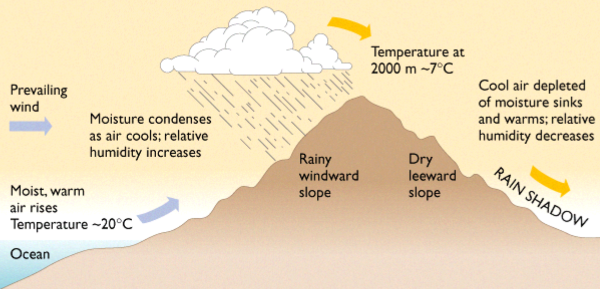
You can find this type of rainfall at some of the earth's great deserts :) The word "orographic" means that it is related to mountains. When moist, warm air from the sea evaporates, the air is forced up against mountain slopes at places with mountains. At the tip of the mountain top, air formed is cooled at dew point, before condensing to form water droplets, which ultimately fall back down as rainfall. At mountainous regions, air drops down over the high ground, gaining temperature and increasing the amount of water it can hold. That is why the flat regions below mountains hardly experience rain, and this area is known as rain shadow. This is a diagram to illustrate orographic rainfall:


3. Frontal rainfall


Frontal rainfall is caused when frontal systems form when warm and often tropical air meets cooler air. Stratiform precipitation falls out of nimbostratus clouds. Nimbostratus clouds are a formless cloud layer that is almost uniformly dark grey. Usually, nimbostratus is a sign of steady moderate to heavy precipitation. It looks something like this:

Scary, isn't it?! ):
Back to the point on warm and cool air. As hot air is lighter and less dense than cold air, it rises over it. As warm air is forced to rise further, condensation occurs at dew point, and over time rain droplets will accumulate, resulting in the scary looking cloud as seen above (because the water droplets block out sunlight from the Sun).


On the other hand, when heavier and denser cold air pushes beneath and lifts the warm air, a cold front occurs. This causes lowered pressure along the cold front and can cause the formation of showers and thunderstorms when enough moisture is present.

Alright, I hope that everyone has learnt a new thing or two through this new entry. Tata for now :)

Done by: Clarissa (7)